We use this interactive map plugin to help organizations present location-based information in a way that’s immediately accessible to their audience.
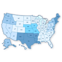
For the National Immigrant Women’s Advocacy Project, we set up a clickable U.S. states map where visitors can click any state to see detailed public benefits information for that location. We connected this to Airtable views so their team maintains one central database that automatically updates the website content.
Benefits
- No coding required with an easy-to-use dashboard for customization
- Each region can be customized independently with colors, links, and hover information
- Responsive design works seamlessly on desktops, smartphones, and tablets
- Simple shortcode makes it easy to embed maps in any page or post
- Integrates with popup plugins to display additional information without leaving the page
The plugin uses modern SVG technology and includes bulk editing options for faster setup. You can set regions as active or inactive, add images and text in hover popups, and choose whether links open in the same window or new tabs. This creates an engaging way for visitors to explore regional information while keeping your team’s workflow streamlined through centralized data management.